Oscar Turns right Around....
56.07k views3381 WordsCopy TextShare
Mr. Weatherman
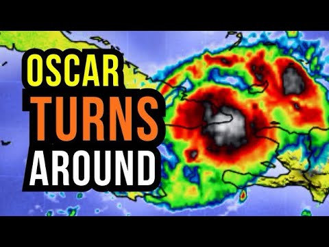
Tropical Storm Turning! In this video, where Tropical Storm Oscar will impact. Where the highest win...
Video Transcript:
thank you very much for joining me on meteorologist Brian Shields all eyes on Oscar of course it has weekend because it's Overland just what we talked about yesterday especially over some of the higher terrain of our friends in eastern Cuba now this is not going to come to Haiti although we'll get some gustier winds at Times Higher seas and we could see some showers and storms so this is more moving up toward Long Island crooked Island as we work uh through parts of the Bahamas it's not in the same form as yesterday again it is
weaker winds right now at about 50 mph 80 km an hour right here and it it it's now making its turn kind of almost turning around as a hole and it'll shoot through parts of the Bahamas then lose its tropical characteristics as it makes its way up toward Bermuda so you see it here uh today starting to pull away as it finishes its turn near Cuba and then working through parts of the Bahamas and then lifting up as we work our way especially into Wednesday uh by that point near Bermuda but at that point not
tropical it's going to lose its tropical characteristics it's going to really get tied into a front it'll move up near Bermuda with some tropical storm wind gust though and then eventually parts of Eastern Canada which I'll cover in just a moment and I want to show you the Windfield on this but still those advisories out we have those tropical storm warnings out especially for parts of Eastern Cuba parts of the Bahamas and we're going to get those gustier winds Central Southern Bahamas no doubt we'll have some stronger winds nothing as a whole we can't handle
uh as I metion mentioned it did substantially weaken but it is now making its that uh turn kind of turning around and then will make its way Wednesday still has about a tropical storm at least early Wednesday and then lose its tropical characteristics and then head toward Bermuda so why is it making this a big kind of a turnaround well it's because of a front this time of year we have those bigger fall fronts that move through the us and this one is going to kind of grab it and help steer it high pressure moves
away a front comes in so it gives it that Alleyway to kind of make its way up right in between that front and that area of high pressure so i' like to show you not just where things are going to go but also why give you the heads up on everything I'm seeing uh out there now this has been a small hurricane now small hurricanes uh can be rough of course now it is a tropical storm uh it's been downgraded but it started as a small hurricane that red shading in there those hurricane winds the
orange shading in here those are tropical storm winds it has now lost its hurricane force winds so now tropical storm very compact very small one of the tiniest I've seen uh but either way tiny or large they they can make an impact and we've seen some down trees in some spots now as far as the winds go these would be the max winds and I mentioned nothing as a whole uh we can't handle as we work our way through the uh Bahamas Now still today we'll get some of those gust uh in eastern Cuba 60
m per hour or about 95 km an hour and then as this works its way through the Bahamas we're looking at Winds of about 50 mes hour or 80 km an hour Northern Bahamas get over toward a New Providence for example this is going to be staying to the South most of it will'll be staying down to the South and fortunately this will not sit in place it is not a Dorian it's not as strong and it's not going to stall out this thing is going to move you see it making its move and then
it will be near Bermuda by midweek and then very close to the Atlantic region of Canada what's left of it as it gets tied into a front down the road this is by about Thursday into Thursday night Newland a better chance of some higher winds and some uh at least some coastal flooding with this as this moves in now still a tropical storm now this is a day out this is the same thing as those squiggly lines I just showed you uh but this is showing the strength of those lines those lines always look a
little bit scarier when something's coming at you but I like to show you well how strong is it going to be or how weak is it going to be well over the next 24 hours this is generally going to hold tropical storm strength two days out still tropical storm strength and then the models kind of get all over the place because it is going to eventually weaken and lose its tropical characteristics as a front kind of gathers this up so what does this mean specifically Bermuda we're in monitor mode this isn't going to be anything
we can't handle we are going to get some gustier winds 50 m hour 80 km an hour on Wednesday as this moves in we're going to get a lot of rain but generally a fast mover so of course watching us in Bermuda and then we get down the road Atlantic region of Canada still from Nova Scotia back toward New Finland uh we we are in monitor mode for the most part everything's shifted a little bit more to the east we're going to see a front Sweeping in so in particular all of us will get the
higher Seas uh but Newland that's where we could have some of the gustier Winds and that flood threat later this week watching on Thursday uh the front is going to combine with the remnants at this point of Oscar and kind of a work up so let me show you that out in time so you can see here right back through here here's Haiti here's Cuba this is later today uh making that turnaround and you see the rain kind of moving through and I mentioned the northern Bahamas look in the northern Bahamas this is all generally
staying to the South still some additional rain Turks and Kos where this all started just a couple of days ago this is by the time we get into tomorrow morning still some tropical storm conditions tomorrow morning then as we go through the day tomorrow it starts to pull away and you look at this map and it doesn't even look like a tropical storm at this point by later on Tuesday later tomorrow because it gets tied into the front kind of gets a elongated it all gets stretched out it's not that circle with an eye or
anything like that it starts to get stretched out so let me stretch out the map for you and show you what we're seeing this is by Tu here's Bermuda this is by Tuesday uh afternoon Tuesday evening so as we get our way into tomorrow and then by Wednesday morning that's when we'll even tomorrow night but Wednesday morning in particular some of the gustier Winds heavier rain through the day on Wednesday and then all of this lifts in but what is steering this look at that front back toward Quebec even some snow back behind it this
is the front right here that is starting to press in kind of helping to grab it steer it and then you see as we work our way into Thursday most of the action is off to the east of New Brunswick off to the east of Prince Edward Island just kind of srting by Nova Scotia but uh New Finland as we work our way into Thursday uh especially Eastern sections that's where we could get some gustier winds and watching the rain and then yet again on Friday another front's going to be working its way back toward
Quebec so as far as the wind goes uh winds go kind of that tiny pocket the uh White shading or seeing in here those would be Winds of 80 km an hour or 50 mph if both units of measurement on there uh to let you know I want to keep everyone uh safe that's why I do this uh channel so you see here again those gustier winds rolling right through Long Island for example as we work our way into uh tonight and tomorrow morning uh winds roughly around 50 maybe 60 miles per hour some of
those those gust around and then this area starts to work our way as we work our way into later tomorrow and then this year is by the time we get into Wednesday morning still some of the elevated Seas but things are going to start to settle down so Wednesday morning stretching things out again here we are in Bermuda you see the gustier winds moving in that white shading there where we could get some of the gust of 50 m per hour or 80 km an hour not really sustained gust tied in with some of that
rain you know the routine doe a lot in Bermuda and then this just kind of works its way up toward uh the Atlantic region of Canada some of those red showing up there winds uh in the open Waters of the Atlantic around 70 mph still some hurri close to Hurricane Forest winds now the onshore flow looks to be New Finland that's why I'm a little more concerned about uh some of the OverWatch or coastal flooding course depends on uh the train exactly where you are offshore as we work our way into Nova Scotia but nonetheless
Friday uh Thursday into Friday we'll have some of those gustier winds especially right along the uh immediate Coastline so here it is right there there is Oscar tropical storm look at that blob right there I've been watching us in Barbados Trinidad all off to the east as of now this is not organized but no I'm watching this now part of this is going to break apart because as Oscar kind of lifts through here it does actually draw some of the moisture in but point being for us across the Eastern Caribbean we're going to stay unsettled
Grenada St Lucia uh Dominica break down the forecast for us and then this out here some of the remnants of naen getting tied into another area of low pressure uh back to the west of us so you can see a few spots this is Oscar this is later today watching that of course there's a A system that is not a name system but watching out for some additional rain just to the east of us in the Eastern Caribbean and then this here the remnants of naen getting tied into another little developing area of low pressure
and this should become a name system as of now it looks like did kind of lose its full circulation so it should be a new name system uh on the Eastern Pacific side it'll grab a different name it won't keep naen because it lost its circulation but tomorrow what's left of Oscar kind of scraping through and then there's that unsettled weather so St luia guadaloop we're looking at had a better chance of some rain and storms at times tomorrow and then there's that spot developing now for our friends in Mexico it doesn't look like this
is going to hook in as this area just develops it's going to be working away you see on Wednesday that continues to pull away from land so that is good news there there's some of the additional rain back toward Bermuda across the Caribbean Dominican Republic Puerto Rico some scattered showers and storms all the way down through Trinidad and there's that spot in the Eastern Pacific that should become a tropical storm and maybe eventually a hurricane as that moves away from land so this here is on Wednesday really active pattern just continuing I brought it out
this map to show you the Seas here's meters here's feed and look how things really as this uh what's left of Oscar will really get tied into the front look how those Seas really build Gulf of Mexico looking good much of the Caribbean okay Atlantic facing Waters though that's where we have some of the issues but those Seas really building as we work our way into Thursday and Friday across parts of the North Atlantic that's why I am concerned about some of that flooding as well but those Seas will be a mess as is H
sometimes typical this time of year with those bigger fall fronts moving in so naen again that the circulation fell apart but the remnants some of the rain have drifted into parts of the uh Pacific Oscar is what we're dealing with now tropical storm Oscar the next name on the list is Patty if we do get another Nam storm I do believe there'll be at least a couple more named storms as we continue forward through October into November end of the hurricane seasons in at the end of November it does look like the Caribbean going to
kind of be the hot spot for the potential of some development and I'll monitor that I've been looking at some longterm stuff behind the scenes but as far as the rain is concerned still some spots some of this oh even some of the yellows popping up just because as it it's kind of turned around it's been hanging out in eastern Cuba so some of the totals around 200 millimeters of rain or 8 in of rain we could see that just as it kind of R over toward Long Island just as it moves its way through
parts of the Bahamas there but this is not coming to us in Jamaica not coming to us in the Cayman Islands it is making that turn but I mentioned the north side of uh Haiti we could get some additional scattered showers and storms and of course again across the Turks and quos Hit or Miss Dominican Republic Puerto Rico but it's staying active sabba Stasia we could get a couple showers over toward St Martin back towards St Croy and then you see St Lucia Barbados that that moisture I was showing offshore down through Trinidad could give
some of us 50 mm of rain or 2 Ines of rain over the next 3 days no wash out but very unsettled as we go throughout the week ahead and that includes parts of Northeastern Venezuela Northern sections of Guyana not as much as we work our way into CERN and still watching out for some of these areas of rain and storms across Central America so B over the next few days we could see some spots over 75 millimeters of rain or three inches of rain same thing Costa Rica back throughout Panama not quite as much
Honduras Nicaragua Guatemala and El Salvador little storming around Mexico City uh to the north especially over toward the Gulfside Bay of Campa we'll see a better chance of some of the rain so for us in Jamaica Oscars not headed our way 40 to 50% chance of scattered showers and storms the next few days Cayman Islands rain chance down about a 20 to 30% chance but you see tomorrow and Wednesday what I was talking about the unsettled pattern Trinidad and Tobago we have a 50% chance and look at the rain chance tomorrow in Barbados we're bumping
up to a 60% chance some of that moisture from the East starts to move in and that will keep us at about a 40 to 50% chance as well in St Lucia not all day but some scattered showers and storms we do it again in Grenada today only a 20% chance but tomorrow we bump up to about a 50% chance in sa F in the Grenadines tomorrow you see that rain chance is elevated a 60% chance 50% chance by Wednesday martinque watching out for some scattered showers and storms tomorrow and Wednesday and Dominique we're going
to do that over the next few days we're looking at about a 50% chance of rain and in this still that chance of a few thunderstorms guadal loopa 50% chance the next couple days isolated Antiga abuda a 30% chance 30 to 40% chance St kits and nevas in moerat rain chance about an even 40% chance the next few days uh inua and St Barts and about a 30 to 40% chance in the next couple of days St Martin saba and staia isolated to scattered showers and storms midweek it'll start to pick up some across Puerto
Rico not a wash out but some scattered showers and storms will do that again us and British Virgin Islands about a 30 to 40% chance as we work our way toward torola and St Thomas and of course Bahamas uh we highlighted that Northern Bahamas were in much better shape but Central Southern Bahamas watching out for some of those gustier winds and those higher Seas as Oscar continues to move by and that includes the Turks and Kos today where all of this did start uh as this starts to make its turn and it has and makes
that a big kind of turnaround we're going to see some scattered showers and storms uh Turks and caos 30 to 40% chance uh Dominican Republic better chance in Haiti will be on the North side so north of Port of Prince as we go throughout the day we're looking at those scattered showers and storms though a 50 to 60% chance we unsettled and then Aruba Kiran boner rain chance about 20 to 30% could be a little bit higher uh later this week with a bit more moisture around Guyana the northern coast better chance of getting some
of the rain about a 30% chance in suram scattered areas of rain across Cuba but of course all eyes on Eastern Cuba as Oscars sitting in place right now as that continues to turn up toward the Bahamas Costa Rica Panama rain chance about 50 to 60 % 50% chance in Nicaragua and we're looking at about a 50% chance of scattered showers and storms in Honduras rain chance has bumped up Guatemala and El Salvador about a 60% chance and you see it it's bumped up as well Mexico City next two days 40 to 50% chance 30
to 40% chance of some scattered showers and storms anywhere from Merida uh back through Cancun down through KML Northern Columbia 30 to 40% chance we do that again in Northern Venezuela and of course uh watching berm UTA we're going to see that a ran chance especially tomorrow night into Wednesday on the very high side as what is left of Oscar moves through with some of those gustier winds so Oscar is making its big turn as that thing turns around watching Cuba back toward the Bahamas Bermuda Canada down the road in the naen remnants in the
Pacific which should uh start to redevelop today and will become a new name system out there so busy pattern in the tropics thank you for getting the word out about where things are going and where things are not going to help lower some of the anxiety this time of the year so watching everything behind the scenes I'll be going through those comments as we go throughout the day be safe and have a good rest of your day
Related Videos

18:43
Two Storms could Form...
Mr. Weatherman
1,371,424 views

13:25
North Carolina continues to search for Hel...
60 Minutes
64,880 views

7:20
Why Does Canada Have A Problem With India?...
NDTV Profit
4,680 views

13:16
This Wisconsin county has backed the winni...
60 Minutes
285,764 views

23:10
Milton gets Stronger and will be a Direct ...
Mr. Weatherman
1,834,895 views

2:57
Jim Cantore vs. Category 5 Winds
The Weather Channel
5,836,641 views
18:06
Hurricane and Tropical Storm Chance Grows...
Mr. Weatherman
1,134,747 views

7:06
MSNBC in meltdown after Donald Trump's McD...
Sky News Australia
1,325,962 views

47:43
Meet the Press full broadcast — Oct. 20
NBC News
204,588 views
5:22
Tropical Storm Oscar Slams Cuba With Torre...
FOX Weather
9,586 views
19:59
Milton will be a Hurricane...
Mr. Weatherman
991,660 views

23:31
Neal Katyal on How Donald Trump Could Over...
Katie Couric
188,880 views
24:05
Milton becomes a Super Dangerous Hurricane...
Mr. Weatherman
1,099,600 views
18:09
Tropics Update: Tropical Storm Laura, Trop...
13News Now
323,322 views

19:46
ABC World News Tonight with David Muir Ful...
ABC News
562,005 views

21:23
This Morning’s Top Headlines – Oct. 21 | M...
NBC News
5,958 views
8:19
Talkin' Tropics: Hurricane Oscar nears Cuba
First Coast News
11,213 views
19:31
Caribbean on Alert for new Storm…
Mr. Weatherman
785,784 views
33:04
Tracking the Tropics: Where will Invest 98...
WFLA News Channel 8
154,770 views
18:20
Sanibel Island, FL Damage Survey Long Raw ...
StormChasingVideo
428,016 views