THE GEOLOGICAL MAP "Drawing the Earth's skin"
60.77k views1040 WordsCopy TextShare

Paleoceno
Video Transcript:
when we hike through the countryside or gaze at a mountain we have the feeling that the landscape surrounding us is unchanging but is that really the case we live on an evolving planet which has been transforming for millions of years and it continues to and don't forget that what we see on the planet's surface is just a small part of the whole under our feet is a wide variety of geological materials rocks sediments minerals and more their presence composition characteristics and formation is what geologists study and their graphic representation is what is known as a
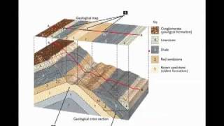
geological map a geological map takes a profound look at which materials crop up on the Earth's surface and how each of these elements is arranged in other words the map is a representation of the geological architecture both above-ground and underground this vital information allows us to make the most of mineral resources such as metals and energy sources like coal and oil it also helps us to locate the water that is filtered into aquifers and to use geothermal energy in addition geological maps are important for guiding agricultural activities but that's not all thanks to geological studies
that are supported by maps we can establish where natural processes are likely to occur including landslides earthquakes floods and volcanic eruptions minimizing the consequences of natural catastrophes actually geologists work begins in the library the first thing they do is to analyze and study any existing work that covers the area where they plan to create the geological map geologists need an overall view of the terrain and any variations in elevation to this end they use pairs of aerial photos these are partially superimposed and used with a stereoscope allowing for a 3d view of the surface of
the area to be studied in less complicated zones with scant vegetation photo geology makes it possible to create a preliminary map which is quite complete accurately pointing out faults and folds as well as classifying materials with this preliminary study geologists can determine which points must be observed directly in the field because there are either complex or representative in nature and now the fieldwork can begin it's not usually possible to analyze every inch of the terrain but geologists guided by the observations they've made using aerial photos follow a predetermined path with key stops known as stations
at each station geologists identify different kinds of materials they collect and study samples of rocks sediments and fossils all of these are carefully labeled and the exact date and location are noted the rocks that make up planet Earth which we can see on its surface are quite varied igneous rocks formed by the cooling of molten rock deep within the earth metamorphic rocks transformed by the great pressure and high temperatures found underground and sedimentary rocks formed by the accumulation of sediment in lakes in riverbeds and on the seafloor sedimentary rocks are deposited in layers of varying
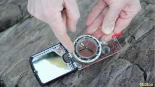
composition as strata usually in a horizontal pattern in order for them to become visible on the Earth's surface they must be pushed upward by the same forces that create mountains through a process known as orogeny during this process which lasts over many millions of years rocks are deformed folded and fractured along break lines called faults using a compass outfitted with a clinometer geologists can measure the direction and inclination of strata and other structures this allows them to recognize different geometric patterns and gather essential information in order to make a three-dimensional reconstruction with the help of
aerial photographs they draw a first draft of the map directly on the terrain marking lines between the different rocks their observational capacity experience and knowledge of other similar phenomena allow them to sketch out large areas of the map all of this information is compiled in their field notebooks or on more modern devices which allow further data to be entered in a geo-referenced manner back in the office geologists contrast the information they have obtained with aerial images and previous studies in order to finalize the map which may or may not be digital standardized symbols provide visual
clues to help us rapidly identify the different types of rock that have been found sandstone limestone and dolomite rocks the age of which is shown by their color the geological age of each rock is an essential piece of data that geologists need so they can put the events that created them into chronological order and examine the geological history of every corner of the planet the evolution of animal and plant species and the success of great biological extinctions make it possible for us to date sedimentary rocks because of the fossils they contain rocks with the same
fossils will be the same age the absolute age of Iraq can be determined thanks to radioactive dating when a rock is formed the minerals have a precise elemental composition some of these are radioactive and therefore become unstable over time we know that they disintegrate in a certain time period giving way to other elements if we measure the proportion of these we can find out the moment the rock was created sometimes many millions of years ago the geological map is not just a flat representation it is also three-dimensional using orientation and inclination data for strata and
faults geologists can draw geological cross-sections and 3d models that show the spatial positioning of different materials located many kilometers beneath the earth's surface once the mapping process is complete field geologists send a rough draft of the map to cartographic specialists for validation once it has been approved and accepted the map is ready to be published in different formats since geological science began hundreds of years ago geological maps have served as a basic tool for geological knowledge and this is still the case the maps are a visual expression of the work of geologists allowing us to
learn what the earth is like today to remember what it was like yesterday and to predict what tomorrow will bring for beneath our very feet although it may be quite slow the earth is changing moving and transforming you
Related Videos

10:59
Steps by step guide for how to map a geolo...
Catherine Mottram
21,179 views

14:13
Hallett Cove Geological Mapping Exercise -...
UniSA Geoscience - Project LIVE
6,434 views
9:07
Folds, Dip and Strike
wvannorden
406,117 views

18:00
The Babylonian Map of the World with Irvin...
The British Museum
2,709,486 views

14:31
The Basques: The Most Mysterious People in...
The History Hub
852,185 views

8:55
JD Vance's bizarre speech will backfire on...
Times Radio
114,909 views

9:38
Sue's favourite Anglo-Saxon sword I Curato...
The British Museum
818,311 views

41:28
From Raw Crystal to Crystal Oscillator - C...
AWA Communication Technologies Museum
584,164 views

19:17
Rock and Mineral Identification
SSFCstudybuddy
3,217,903 views

16:19
A Labour crash is coming | Andrew Marr | T...
The New Statesman
109,676 views

16:04
Identifying Minerals -- Earth Rocks!
Earth Rocks!
591,148 views

14:52
70) Strike and Dip measurement and reporting
CVshorey
92,296 views

14:11
Inside Africa's Food Forest Mega-Project
Andrew Millison
4,696,450 views

9:41
73) Field Geology Preparations
CVshorey
6,822 views

19:22
Full Speech: JD Vance Shames Europe Leader...
Hindustan Times
184,873 views

14:18
Identifying Metamorphic Rocks -- Earth Rocks!
Earth Rocks!
407,461 views
4:18
GEOCOAST - Using Geological Compass: Measu...
GEOCOAST
204,636 views

29:02
The Clock That Changed the World (BBC Hist...
leedsmuseums
1,316,192 views

16:59
Structural Geology Lesson 3: Outcrop Patte...
Blake Splitter
126,016 views

13:27
Drawing a Geologic Cross Section
Oregon State University Ecampus
219,308 views