The ROV glides slowly over the unfamiliar landscape. [music] The team sees small pieces of debris appear on their monitor. The debris field grows as larger and larger pieces of a ship appear, [music] scattered on the seafloor.
Is this the Japanese ship they're looking for? They spot a valve wheel, but the writing they need to identify the ship is covered in silt. [music] Commissioned in August 1942, the battleship Mousashi was one of four planned Yamato class super battleships to be built for the Imperial Japanese Navy.
Only two were built, Mousashi and its sister ship, the Yamato. The third was converted into an aircraft carrier, the Shinano, and the fourth was scrapped before being completed. The Yamato class super battleships were built in secrecy without the allies ever seeing one until they encountered Mousashi in 1944.
The Imperial Japanese ship Mousashi was 263 [music] m long, about 6 m shorter than the Titanic, and was also thought to be unsinkable. [music] It was heavily armed with nine 460 mm main guns, the biggest guns ever [music] mounted on a battleship with a range of 24 mi. It had a dozen secondary guns at 155 mm and carried 52 types of anti-aircraft guns of various [music] calibers.
As the war progressed, the Japanese Naval High Command realized that naval aviation posed a much bigger threat to warships [music] than enemy surface ships did. So in 1943, Mousashi was refitted with heavier anti-aircraft [music] defenses. Six of its secondary guns were replaced with 25mm anti-aircraft guns [music] for a total of 125 anti-aircraft weapons.
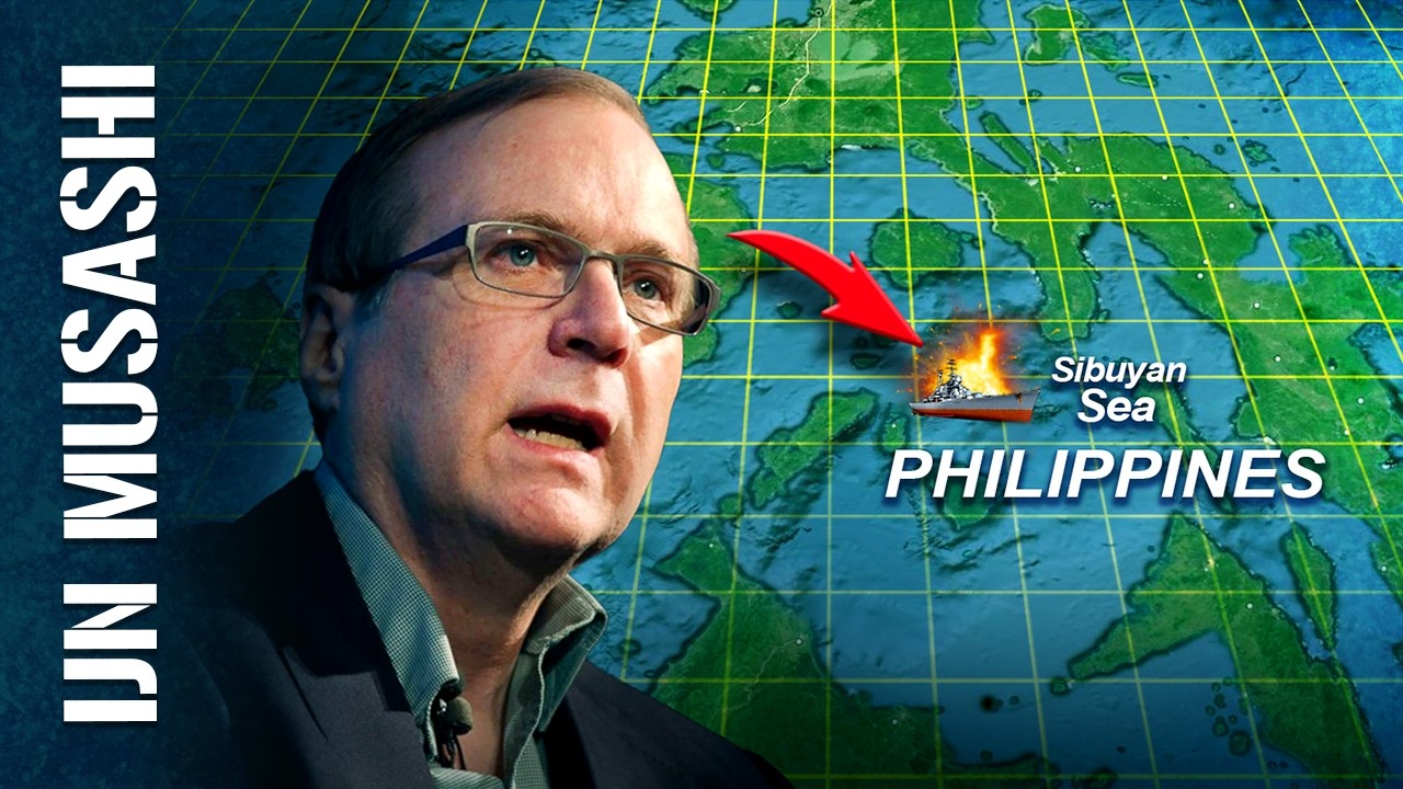
Mousashi was heavily armored with metal plates ranging from 50 mm [music] to as thick as 410 mm. It could also stow seven reconnaissance float planes at the stern and had two catapults to launch them. On the 24th of October 1944, during the battle of Lake Gulf, the Japanese fleet including Mousashi were transiting the Cibuan Sea in the Philippines when they were spotted and attacked by aircraft from six US Navy aircraft carriers.
From 1027 to 1530, six waves of fighters, torpedo bombers, and dive bombers attacked the fleet. Five waves of attack concentrated on Mousashi, hitting the ship from all sides. And with no Japanese air cover to help fend off their attackers, Mousashi was overwhelmed by a swarm of more than 150 aircrafts.
A plane from the last wave documented the attack and the dying moments of the monster battleship. In all, Mousashi suffered 19 torpedo and 17 bomb hits, as well as 18 near misses. By comparison, 3 years earlier in Pearl Harbor, 15 torpedoes and 19 bombs sank all eight battleships.
At 1936, 4 hours after the last attack, the mortally wounded battleship capsized and sank intact, taking 1,023 sailors to their watery grave, including the captain. 1,376 survived. As the battleship sank, crew on board the destroyer Koshimo saw secondary explosions.
Because Masashi was the symbol of pride of the Japanese fleet and important to the nation, its sinking was kept secret from the people of Japan. It wasn't until December 1944 that prisoners of war confirmed the sinking of Mousashi during interrogations. Lost in the depths, Mousashi's location is a mystery.
Over the years, there are many failed attempts to locate the remains of one of Japan's biggest battleships. One wreckinder with his sights on Mousashi is Paul Allen, the billionaire co-founder of Microsoft. Alan's father is a World War II veteran, and listening to his dad's stories [music] piqued his interest in World War II ships.
Later in life, he channeled his passion and resources to locating shipwrecks from the war. He's developed a research [music] team dedicated to this cause. They've spent years looking for Rex.
In 2007, Allan and his team [music] set their sights on Mousashi. His researchers spent years slowly gathering information [music] from US and Japanese military archival records, looking [music] for clues that will lead them to the battleship. They find the official US Navy position of the [music] recorded sinking site of Mousashi, together with photographs of the attack.
On the Japanese side, the team tracks down the official Japanese Navy sinking position [music] and a copy of the log book from the destroyer Koshimo from the time it stood by assisting in [music] the rescue of Mousashi's crew. They gather accounts from the survivors and they find a drawing that indicates where [music] the ship sank in relation to nearby Sabuyan Island. Alan's team uses the clues and coordinates gathered during the research to narrow the search area to a 360 square [music] nautical mile patch in the Sabuyan Sea.
On the 8th of February 2011, 4 years after they start their research, Alan sends his team on a 3-week expedition to search for the missing battleship in the Sabuan Sea in the Philippines. to prevent independent salvagers or tomb raiders from desecrating the site. He tells the team that if they find the wreck to respect it as a war grave and only share the location with the Japanese government and museums involved in documenting any artifacts.
Alan appoints Robert Croft to lead the search. Croft is in charge of all subcerations at Vulcan Inc. which is Allen's holding company that manages his diverse business activities and philanthropic projects.
Alan also commisss David MS [music] to assist in the search. MS is an experienced and successful deep sea shipwreck hunter from Bluewater Recoveries. The team charters research vessel Juke for the expedition.
350 nautical miles is a large area to cover and so Craft and Moons make their best possible guess at where to start. They use a drawing from one of Mousashi's survivors along with the US Navy's aerial photographs of Mousashi's bombing as an initial visual reference. They look for recognizable features and compare them to the photos taken of the burning Mashi with the outline of Subuyan Islands mountains in the background to the south.
Next, they take the logbook entry of the position of Mousashi sinking from the destroyer Kiroshima to narrow the search area. They superimpose a number of grids onto a chart of the area to establish their search pattern. The team plans to create a bathometric survey of the seafloor by following the grid lines.
Alan's team plans to use a sidecan sonar which emits sound waves that bounce off the seafloor or any other object it hits to detect features or objects rising from the seabed. The bouncing sound waves are then picked up by the device and an image of the seafloor is mapped. The sidescan sonar is commonly used to find potential shipwrecks because it's easy to deploy and can cover a large area very quickly by mapping the area on both sides of the sonar.
[music] The resolution of the large area it covers isn't fantastic, but quickly shows any large and unnatural shapes clearly against the backdrop of the normal flow of the underwater terrain. Research vessel Juke toes the sonar sensor at a consistent depth as the ship follows the path of the search grid. The research team watches the sonar image on a monitor as it maps the sea floor.
But Duke only covers a short distance when the sidescan sonar gets snagged on a long fishing line. The Sabuan Sea is a busy waterway and local fishermen use long lines to catch tuna and other fish. The team [music] switched to the multi-beam echo sounder mounted on Juke's hull.
It works the same way as the sidecan sonar, but its field of view is smaller, mapping an area about a mile wide directly [music] underneath the ship. The mapping process takes longer than sidescan sonar, but it is more detailed. [music] The team starts at the western side of the search area, moving eastwards while following one of the grids.
It takes the search team 4 hours to cover one stretch [music] of the grid. The resulting image is a very detailed map of the sea floor about a mile wide. As Duke follows the grid and scans the seafloor, the team looks for a dark object to show up in the map.
This would indicate the reflected image of a man-made object lying on the seafloor. After 4 days, the team finishes scanning and mapping the target search area. They have a detailed picture of the seabed, including a newly discovered underwater mountain, but no trace of the battleship Mousashi.
The location they've estimated for where Mousashi sank based on the log book from the destroyer Kiroshima isn't accurate, so the team has to rethink their strategy on how to expand their search area. Their next clue is the aerial photograph. MS makes up a cardboard box to mimic the field of view of the camera used by the US airmen who took the photo.
Viewing through the cardboard box, he approximates that Mousashi is 2 km closer to the island than their original reference point. He also believes that Mousashi sinks 4 hours after the time the photo is taken, [music] and it drifts in a westerly direction. He overlays this new search area over the one they've already mapped, which extends the western area of the search grid.
On the [music] 22nd of February, 2 weeks into the search, their sonar reveals a promising target. So, the team makes several passes over the target area to map the object. The object is 100 m larger than what they're looking for, and they come to the conclusion it's [music] just a rock formation.
After 3 weeks, the expedition comes to an end. And although they didn't find any trace of Mousashi, they're able to search an impressive 1,057 square nautical miles in 3 weeks, an area roughly the size of Long Island, New York. The team now has more or less an accurate map of the seafloor.
The only thing that restricts the map's detail is the large volcanic ridge that dominates the search area. Depths on the slope of the volcano drop from 150 m to over 2,000 mters within a short distance. It's a steep slope, and the multi-beam echosounder can really only map a surface from above, not the side of a steep wall.
To continue the search, the team needs a better tool for the job. In February 2015, 4 years after their failed expedition, Craft MS and their search team returned to the Sabu Sea with motor yacht Octopus, Allen's luxury yacht. Octopus is one of the world's longest yachts at 126 m.
It carries two submersibles, a 10-seater sub called the Pagoo, and a remotely operated vehicle called the Octo ROV, and it can accommodate two helicopters in its hold. It's equipped with high-tech navigational and state-of-the-art deep sea equipment. Alan has a new toy, the Bluefin 12 autonomous underwater vehicle or AUV.
This custommade AUV is designed based on the search team specifications and it's capable of diving to a depth of 1,500 m. It's a prototype, so a representative of Bluefin Robotics is on board to oversee its operation. and an expedition on a luxury yacht probably doesn't hurt.
The AUV is equipped with side scan sonar. It can conduct a consistent sonar survey across large, deep areas of irregular terrain to give a baseline result. This will show the team where to make a further detailed investigation.
They want to find out what the volcano looks like in greater detail and to see if there's any wreckage scattered along the slope, under rock outcroppings, or [music] inside the crater. They program a survey route into the AUV system using the map of the volcano that was compiled during the 2011 expedition. Lufin 12 is nicknamed the mountain goat because it navigates the rocky and uneven slope without any intervention from the surface until it surveyed the entire underwater volcano.
The research team lower blue 12 into the water and it descends towards the base of the volcano 1,000 m below the water line and 100 m above the sea floor. As the robot travels to survey the area, it maps the terrain and tries to identify man-made objects among the rugged volcanic outcrops. Blufin 12's maximum search range is 389 km and it can stay down for 24 hours, but after 18 hours, the team bring the AUV back to the surface to download the first batch of data.
They analyze the mapped images of [music] the bottom to see if there are traces of the wreck, but after pouring over the detailed map, the AUV survey yields nothing. They put bluefin 12 back in the water to continue mapping the volcano. But the second survey also gives no significant results.
After searching a large portion of the primary search area, the team is disheartened. Only a small area is left unmapped. On their third run, they slowly and carefully check the results, hoping something [music] is there.
Each run has taken over 18 hours. This expedition in February 2015 is the final result of eight years of research, factf finding, [music] and unsuccessful attempts. They've surveyed most of the search area.
If a detailed survey of the volcano slope shows no results, they'll have to go back to the drawing board. As the computer churns out the results, the map shows small dark objects indicating a back scatter of man-made objects on the seafloor. Since they [music] look too small to be a ship, the team isn't sure what they're looking at.
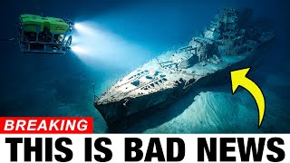
On the 2nd of March, they launch a remotely operated vehicle or ROV to get a closer look at the anomaly. Octo ROV is about the size of a VW Beetle. Unlike the Bluefin 12 AUV, it's controlled by a pilot and co-pilot from onboard motor yacht Octopus.
[music] It's tethered to a cable that carries power to operate the ROV and fiber that transmits video feed from the onboard cameras. [music] Octo ROV can dive to 3,000 m and takes an hour to reach the sea floor more than a kilometer deep. As Octo maneuvers across the seafloor, [music] craft ms and the ROV pilots see small pieces of man-made debris on the screen.
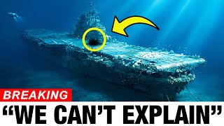
The ROV slowly moves across the unfamiliar seascape. And [music] after 45 minutes, heavier debris comes into focus, scattered on the sea floor. It's a ship, but is it Japanese?
[music] They spot a valve wheel with etchings that look like writing, [music] but it's covered in silt. Moving closer and focusing on the characters, they recognize the Japanese writing. The excitement [music] quickly turns to intense focus.
To confirm it's the Mousashi, they need to find something from the ship with the name. As the Octo RV glides over the debris field, they spot what looks like a bow section with tie up points for muring lines sitting upright on the sea floor. The ROV pilot maneuvers Octo slowly to the front of the bow where they see a round faded teak wood seal measuring 1.
2 m in diameter. While the gold paint is gone, the outline of the Imperial Japanese Seal, the chrysanthemum is still [music] visible. The chrysanthemum is the Empire symbol used only on capital ships of the Imperial Japanese Navy, like carriers and [music] battleships.
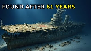
The wreck is indeed the Mousashi. After 8 years of [music] searching, Alan's team has found the monster battleship's resting place at an average depth of 1,185 m, some distance [music] from where the destroyer Kiroshima reported its sinking position. Mousashi's remains are scattered [music] across the side of the Subsea volcano and protected from above by rocky outcrops.
The search team expected to see the enormous battleship resting intact on the seafloor with its majestic [music] 460 mm guns pointing into the distance. Instead, it's cut up into small pieces scattered along a rocky [music] slope. The once majestic battleship is completely destroyed.
Octo explores the bow further and the team noticed that the 150 ton anchor on the starboard side of the bow is intact, but the port side anchor is missing. Based on survivors accounts during its final hours, Mousashi listed to port, forcing the crew to cut and release the port side anchor in an attempt to write the ship. They see torpedo damage to the port bow with several hull plates bent outwards.
The gaping hole is caused by Mark13 torpedoes launched by the attacking bombers, hitting Mousashi four times, almost all in the same place. Each torpedo weighs 1 ton and packs a massive 272 kg of explosives. The US Navy's torpedo bombers scored 10 hits to the ship's port side and nine to its starboard side.
Along with the visible torpedo damage are signs of near misses on the [music] Mashi. A near miss is not a direct hit on the ship, but a bomb or shell detonation close to the ship. The damage of a near miss is still devastating to Masashi.
Parts of the metal hull are depressed and folded upwards by the force of these explosions. The broken end of the bow shows the forward barbit of the 460 mm guns. A barbit is a circular armored housing.
The gun turret is normally mounted in place over the barbit. The gun mount, which houses three 460 mm guns weighing 2,800 tons, is mounted over the barbit and held in place by gravity, but it's nowhere to be found. It dropped from the ship when Mousashi [music] capsized.
Over the next two weeks, the team thoroughly surveyed the debris field, documenting, tracing, and identifying parts of the wreck mousi scattered over an area that measures 880 m end to end and 500 m wide, almost half a square kilometer. The bow and the stern sections are the only complete parts of the ship, although [music] the stern is upside down and was crushed by implosion as it descended to such a great depth. As they pan Octo's camera over the stern, they see the 5 m wide port propeller, one of four that propelled the battleship to a top speed of 28 knots.
The shaft is broken and bent, most likely damaged on impact when it slammed into the seafloor at an estimated sinking speed of between 15 and 25 [music] knots. The massive rudder measuring 11 m by 6 m is also visible. The forward [music] superructure with its sleek and tall pagod style design measuring 11 stories high has [music] detached and lies on its port side.
The uppermost deck 11 is the air defense command station with an elevator to reach the top. Bomb damage is visible [music] on the bridge and its superructure. Mashi is said to have been hit by 17 armor-piercing bombs, each weighing between 227 and 97 kg.
>> [music] >> As the team guide Octo RV across the debris field, they find the float plane catapult scattered on the silty bottom. They see that one of the rails has instructions on the side. The pilot takes a photo of the writing for the team to translate.
Mace was equipped with five float planes, each kitted with K8 reconnaissance cameras stored [music] in its stern deck when it went down. Amongst the twisted metal scattered on the seafloor, the crew see a shoe, a helmet, and even a strip of film from the cameras. After a week of searching, they finally locate one of the 460 mm gun turrets, [music] the triple guns buried in the sand.
There are no available drawings of Mousashi, and they have only a handful of photographs to compare with the wreckage. The team compiles over a 100 hours of detailed video and thousands of photos of the wrecked battleship. [music] On the 13th of March, the search team makes a live broadcast of the Mousashi wreck from the waters of the Saboan Sea in central Philippines.
[music] It's streamed worldwide and is wellreceived, especially in Japan, where the remaining survivors and relatives of those who perished find some closure for their loved ones after 70 years. The broadcast alerts the Philippine government of the search team's presence. Fearing Alan's team will salvage Mousashi without proper authorization, the Philippine government intervened, forcing Motorach Octopus to quietly leave the scene.
At the same time, Allen's team released the following [music] statement. Mr Allen and his research team are mindful of the responsibility related to the wreckage of the Mousashi as a war grave and intend to work with both the Japanese and Philippine governments to ensure the site is treated respectfully and in accordance with applicable traditions. In March 2016, a group of Japanese experts gathered in Tokyo to study the specifics [music] of Mousashi's sinking.
Using the 100 hours of video footage and images documented by Alan's [music] team, the Japanese experts were able to recreate a 3D model of the battleship's debris field. Like a jigsaw puzzle, they began assembling the parts and recreated a model of Mousashi. To better understand how the battleship was constructed, the experts visited the shipyard where it was built, the Mitsubishi Nagasaki shipyard.
During their visit, they stumbled across 200 neverbeforeseen pages of original blueprints for Mousashi in the shipyard's archives. [music] Comparing the 3D model with the blueprints, the experts found out that Mousashi's armor plating was so thick that welding the plates together [music] was impossible. The armor plating was hot riveted together in a process where glowing hot rivets were inserted through precisely drilled holes and the unformed ends were hammered to close the joints.
As the [music] rivet cooled, it contracted and squeezed the joint tightly together. When torpedoes struck the hull of Mousashi, the explosive force caused the rivets to fail, leading to [music] flooding in the vessel, eventually capsizing and sinking Mousashi. Based on a computer simulation, the secondary explosions seen by the sailors on the warship Kiroshima were caused by an exploding magazine compartment.
This was traced to the magazine of the second main gun located near the center of the battleship, where an estimated 160 shells and 100 tons of gunpowder was still stored [music] inside this gun turrets magazine when Mousashi sank. The computer simulation showed that the explosion in the ship's core splined Mousashi into hundreds of small pieces with only the bow and stern remaining intact, exactly how the wreck rests on [music] the sea floor. In December 2017, Alan's team returned to the Philippines, this time passing through [music] proper channels.
The National Museum of the Philippines gave them permission to explore [music] other World War II era shipwrecks within Philippine territorial waters, focusing specifically on the areas where key battles had taken place during October 1944.