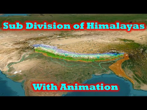
Subdivisions of Himalayas: TransHimalaya, Greater Himalaya, Lesser Himalaya, Shivalik with Animation
4.27k views2543 WordsCopy TextShare
Zeta Axis
💥 *Himalaya formation and classification*
👉🏻 Process of formation and upliftment of Himalayas(Gre...
Video Transcript:
[Music] hey guys welcome to another video of Z AIS and today we will discuss about subdivisions of Himalayas we have already made video on the process of formation of Himalayas where we have discussed how Himalayas were formed then in another video we discussed about the F mountains and fault boundaries in himal as and in the third video we discussed about formation of syntaxial bands and the structure of Himalayas so if you have not watched this video then I would request you to watch these videos in this video we will discuss about different subdivisions in Himalayas
now we know that Himalayas was formed due to Collision of Indian plate and Eurasian plate here we can see current boundary of Indian plate and we can see that because of the Collision all along Ong this boundary we see formation of mountains but not all of these mountains are called Himalayas now during the Collision we see that the compressive forces on the western edge of Indian plate acted in Northwestern Direction creating chain of mountains in North South Direction while on the Northern edge of Indian plate the compressive forces acted in North Direction creating mountains in
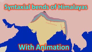
east to west Direction moreover during and nature of these forces also varied that is why mountains on the western edge are called kther mountains and suan mountains and they are not considered part of Himalayas the compressive forces on the western edge and the northern edge of Indian plate were acting in different direction therefore we see formation of syntaxial bends on northern eastern edge of Indian plate these syntaxial bends can be seen as bends in orientation of mountain chains moreover these syntaxial bands presence can be clearly seen in flow of Indus River which takes a sudden
Southward turn near our nanga parvat this turn is due to the formation of syntaxial bands similarly on the Eastern edge of Indian plate the compressive forces during Collision acted in eastern Direction creating mountains running in north south Direction these mountains here are called purvanchal mountains or Northeastern Himalayas in India while in Myanmar they are called Aroma mountain ranges again due to difference in direction of compressive forces on Eastern Edge we see formation of syntaxial forces on the northeastern margin of our Indian plate these syntaxial bands is clearly visible in the form of Bend in the
mountain chains the syntaxial bands presence can be clearly seen in flow of brahmaputra River where an eastwards flowing brahmaputra river suddenly takes a Southward St and enters arunachal Pradesh this occurs because of presence of syntaxial B in Himalayas over here so only the mountains in between the syntaxial bands is called Himalayan Mountain system the western edge of Himalayan Mountain system is marked by indas river near the nanga pvat peak while the Eastern edge of Himalayan system is marked by brahmaputra river near the namara peak now if you look at the location of Himalayan Mountains we
can see that in the north the Himalayan Mountain system is bounded by P not and Konan in the northeastern direction we see tiban plateu on the western side we have Hindus mountains and suan mountains while in the Eastern side we have purvanchal Himalayas and towards the South we have indog gantic and brahmputra plains the Himalayan Mountain system is further divided based on the origin of these mountain ranges during the Collision there were three major regions the first was uran plate the second was teis oan flow and the third was Indian plate the mountains which were
uplifted from Indian plate are called Himalayas which includes greater Himalayas lesser Himalayas and Cales or outer Himalayas the mountains which were uplifted from uraan plate and tees are called trans Himalayas in our ncrs however if you refer to any major work on Himalayas we can see that the mountains north of Himalayas are further classified into two parts the mountains formed from teis oan floor is called Tean or tibetian mountain range while the mountains formed from uran plate is called trans Himalayas now let's further see in detail subdivisions of Himalayas and trans Himalayas so let's start
with trans Himalayas they were formed around 80 to 65 million years ago from uran plate due to wanic activity and therefore they are mainly comprised of volcanic and granitic rocks trans Himalayas are 1600 km long and its WID varies from 225 km to 40 km the first major range of trans Himalayas is kakura mountain range karakoram mountain range is another most mountain range in Himalayan system karakoram Mountain starts from pin not in the west and extends around 600 to 800 kilomet in the East it covers whole of ladak and reaches the Chinese region the southern
margin of karakuram is formed by indas river in its western side and sok River in Central or Eastern side karakonam ranges are one of the L sest ranges in the world they have several mountain peaks above 8,000 M range the elevation in karakuram rarely Falls below 5,500 M Mount K2 also called Mount Goodwin Austin located in PO is the second highest mountain peak in the world and it is located in karakonam range in karakonam range we find karakoram Wildlife century and Chang Tang Wildlife Century the famous pangong lake is also located in foothills of karakuram
range in Chang Tang Wildlife Century karakonam range is also home to many large glaciers in the world outside of polar regions these glaciers include siin glacia baloro Glacier bog Glacier hisper Glacier and batura Glacier the cin Glacier is the longest glacier of India along the southwestern margin of sein Glacier we we have saltoro range which is a sub range of karakuram range this range defines the boundary between India and Pakistan in this region this boundary is called actual ground position line the peaks of this mountain range were captured in 1984 under operation mud by Indian
army just weeks before Pakistan's plan to capture the Peaks we will discuss more about it in detail when we discuss Indo Park relations next important mountain range in trans Himalayas is ladak mountain range it runs from the Confluence of indas and COK River in baltistan P to Indo tibetian border for most of its part indas river forms its southern boundary ladak range was also formed due to volcanic activity therefore it is also formed of granitic and volcanic rocks sto kangri in northern part of hemis National Park is the highest peak in the region the climate
in this region is mostly cold arid due to low rainfall the extension of ladak range in tibetian region is called kalas mountain range or gangis in Chinese the highest peak of this range is Mount kalas and near Mount kalas we have two important lakes lake Ras and bover Lake the Eastern section of Himalayas is called nichen tangla Mountain it runs north of brahmaputra river and parallel to Himalayas on Eastern margin of trans Himalayas on the east of brahmputra we see a part of trans Himalayas extends southwards in arunachal Pradesh this part of trans Himalayas is
called kangri carpo this range extends in arunachal prades till mismi Hills which is located on the boundary of India and Myanmar now moving forward to Tean Himalayas the Tean Himalayas are separated from trans Himalayas by in the suture Zone the suture Zone basically means a tectonic line along which two continental plates collide and join with each other so IND theang suure zone is the region where indiian plate comes in contact with uraan plate now let's move on to tiian Himalayas or tiban Himalayas now the tiian Himalayas or the tibetian Himalayas were formed due to upliftment
of teis oan flow that is why we see large amount of fossils and sedimentary rocks in these mountains average width of Tean Himalayas is 100 kilom making it broadest zone of Himalayas the major range of tees Himalayas is jar range it extends from suru River in Kil to Kali River or Kali River on Indo Nepal border jusa range is mainly found in ladak Union territory and utarak the mountains do not show significant presence in Himachal Pradesh the highest peak of jcar is Mount K located in utarak while Mount Rio puril is located on Himachal China
border hemis National Park is located in jasar range between indas and jcar River kibber Wildlife century and gangotri National Park also cover some parts of jcar range now let's move on to Himalayas the Himalayas is separated from trans Himalayas or Tean Himalayas by South tibetian Detachment the northernmost part of Himalayas is called greater or higher Himalayas these are a continuous chain of mountains from n a perva to namcha Bara the range has very few gaps mainly provided by antecedent Rivers like satl gagra kosi brahmputra or SOS due to compressive forces acting from Southern side during
the upliftment of Himalayas the southern slopes of all Himalayan mountains are steep compared to Northern slopes the greater Himalayan rocks experienced very heavy compressive forces during the upliftment process causing crystallization and metamorphosis of the Rocks therefore the greater Himalayas range mainly have crystalline ignas or metamorphic rocks greater Himalayas has an average height of 6,100 M and it is 25 km wide greater Himalayas is home to some of the loftiest mountains in the world some of them include Mount Everest kchan janga manasu L dhiri Anapa badrinath nand Dei nanga parvat nunun mountains in Greater Himalayas in
the jamu and Kashmir Union territory region we find dingham National Park and kavar National Park Pin Valley National Park kir ganga National Park and greater Himalayan National Park are present in Himachal Pradesh region of Greater Himalayas gangotri National Park Valley of flower National Park and nand Devi National Park which is also part of a biosphere Reserve is located in utarak and are part of Greater Himalayas the Ken janga National Park of sikim is also located in Greater Himalayas Ming National Park in arunachal Pradesh is also located in Greater Himalayas greater Himalayas is also home to
many important glaciers which are source of of important rivers some of the important glaciers of Greater Himalayas are Dair Glacier near nanga parvat Rupal Glacier safat Glacier and Drang drun Glacier of Jammu and Kashmir babush Glacier from which yamuna originates and gangotri Glacier from which ganga originates are both part of Greater Himalayas and are located in utarak utak also has mam glacia Pinder glacia and Mana glacia the zamu Glacier of sikim is also a part of Greater Himalayas now let's discuss about lesser Himalayas main Central trust separates greater Himalayas from lesser Himalayas lesser Himalayas is
formed of metamorphosed sedimentary rocks and minor volcanic and granitic rocks it is about 80 km wide with an average height of 1300 to 4600 M lesser Himalayas houses some of the famous Hill stations of India like Simla masuri ranik nital Alora and dling ler Himalayas can be further divided into sub ranges the first and most important is p pel range the Lesser Himalayas in the Jammu and Kashmir region is called p panel range it extends from kissen ganga River in the north till Bas River in Manali P pel range is the largest section of of
lesser Himalayas de Tiba and indasan mountain peaks are the two most important mountain peaks of P panjal range indraa National Park is also located in p panel range the P pel separates Kashmir Valley from Jammu region and therefore we see there are many passes which connects cities in both these regions the javahar tunnel under banal pass connects banal and kazand while atal chel under rangas is also located in p panel range rangas in eastern P pel range also connects Manali and lul in between p panel and greater Himalayas is located Kashmir Valley which is famous
for Cara deposits we will discuss Kashmir Valley and Kwa formation in detail in another video now the next part of lesser Himalayas is dhadar mountain range the Le Himalayas in Himachal range is called dhadar mountain range it starts from Delhi and stretches across Himachal Pradesh it merges with P panal range near Manali the highest peak in dhada range is Hanuman Tiba which is about 5,980 M dhad ranges are formed only in Himachal Pradesh they do not spread to other states of India the kangra valley lies between lesser Himalayas and calik in Himachal Pradesh in utarak
the Lesser Himalayas are split into two branches the first is called masuri range which is located very close to dadun City the highest peak of masuri range is masuri the next part of lesser Himalayas is nakba and it is parallel to masuri and it extends till Nepal border the goind pasu vhar National Park is located in nakar range after nakba the Lesser Himalayas enter Nepal where they are called Mahabharat Lake now moving forward let's discuss about civa Lees siiva Leakes are separated from lesser Himalayas by main boundary thrust civa leagues which extend from jamu to
Assam in the East has an average elevation of about 900 to 50 00 M and the width of calik varies from west to east it is wider in the west and very narrow in the East the maximum width of calik is 45 kilm while its minimum width is as less as 8 km cival Leakes for most of its part are continuous mountains except for a 80 to 90 kilomet Gap in West Bengal between Tista river and ryak river the siiva Leakes in Jammu and Kashmir region is called Jammu Hills in uttar Pradesh we see an
extension of cival Leakes entering into uttar Pradesh which is called dudar in Nepal the Sia Leakes are called chats in arunachal and Assam region we see that siiva leik mountains can be further divided into smaller mountain ranges like dafla Miri abore and mismi the southern slopes of civa Leakes in eastern part of Nepal to Assam is covered with thick forests which are called terai Forest but the forest cover sharply decreases in western region due to decrease in rainfall the southern slopes of cival Lees is home to a large number of national parks and wildlife centuries
some of the important ones are rajaji National Park and corate National Park in the utarak dwa National Park in up waliki national park in Bihar Jala praa and bua National Park in West Bengal while in Assam Rona Manas and Nami national parks are located in foothills of siiva Le in between siiva Leakes and lesser Himalayas we see large number of longitudinal valleys which are called Dunes in the west and DS in the East the deun is an example of this kind of dun Valley some of the important Dunes are kotle dun and udhampur dun we
will discuss the formation of Dunes in another video in detail I hope you have liked our video and if you have liked this video then please subscribe to the channel and share it with your friends thank you for watching the video
Related Videos
4:11
Formation of Syntaxial bends in Himalayas ...
Zeta Axis
5,678 views

20:23
Indus river system - Jhelum, Sutlej, Ravi,...
Zeta Axis
3,001 views

19:11
Process of formation and upliftment of Him...
Zeta Axis
13,221 views

12:38
When India Was An Island
PBS Eons
1,306,008 views

19:09
How China Uses Mexico To Avoid U.S. Tariffs
CNBC
870,103 views

54:18
Current affairs 2024 (Lecture 8) | UPSC ...
GENIUS IAS
31 views

9:22
Eastern Ghats-Velikonda, Nallamala, Palkon...
Zeta Axis
24,458 views

21:54
Indian Monsoon rainfall and Retreating mon...
Zeta Axis
12,417 views

8:36
Mountains of North East India with Animation
Zeta Axis
4,055 views
16:51
The Geography of Himachal Pradesh
Harshit Rautela
387,482 views
24:50
A Brief History of Colorado Through Time ...
igpcolorado
1,368,014 views

1:13:14
David Reich, "A Tale of Two Subcontinents:...
Harvard Science Book Talks and Research Lectures
158,149 views
6:10
Vindhya mountains - structure and geology ...
Zeta Axis
8,618 views

7:01
How DECCAN Plateau Was Formed ? | Indian G...
OnlyIAS UPSC
187,189 views

15:18
A Helicopter Flight to Mount Everest Base ...
Gorakh Bista
4,062,414 views

7:07
How India Crashed into Asia and Changed th...
Think English
3,867,566 views

13:08
Indian Tectonic Plate is Breaking into Two...
StudyIQ IAS
2,023,590 views

14:14
Incredible India 4k - The Real India Revea...
Explore India
1,651,286 views
![Birth of Himalaya // How Himalayas were formed [12+]](https://img.youtube.com/vi/YqQhV1PwnX4/mqdefault.jpg)
8:54
Birth of Himalaya // How Himalayas were fo...
Survivor's Stories
15,066 views