Projeções Cartográficas: Plana, Conica e Cilindrica - Entenda Agora
124.95k views893 WordsCopy TextShare
geo ilustrada
Neste vídeo vc vai entender os três principais tipos de Projeções Cartográficas, que são as Planas, ...
Video Transcript:
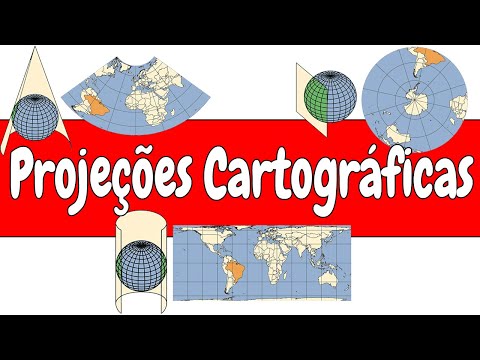
And as you know, there are several types of maps, each one with its specific characteristics and uses. In this video I present What are the main cartographic projections and their main characteristics, all in a direct and objective way. in college entrance exams and if you have no idea what cartographic projections mean I'll start by explaining that well the projection is nothing more than the transformation of a sphere and a flat drawing That is, you take the planet earth there that As you know is circular not flat and project it On a flat surface a paper a sheet this all through a system of meridians and parallels on which the map can be drawn if it makes you confused I have already recorded a video here on the channel explaining this topic better link here on the card and also in the description and this transformation of a spherical surface into a plant It's extremely complex and that's the big problem in cartography But why is this so complex because it is impossible for you to project a spherical surface on a plane without deformations happening because of that we look for projections that allow to reduce these deformations that of course according to the desired application So you have to know that all maps has distortions in projection will privilege some aspects to the detriment of others and we are going to talk a little about this now that they are the properties of a map the first of them is the equivalent projection in this type of projection does not change the areas represented because it maintains a constant relationship with the corresponding areas, that is, the areas maintain a relationship of proportionality with each other the second type are the conforming projections of this type of projection not the deformation of the angles at any points on the map the main characteristic of this type of projection is that it does not form small regions the third type are the equidistant projections in this type of projection there is no deformation linearizations for some lines because it is mainly concerned with preserving the distances but with a deformation in the areas Let's go there for the last type so we can finally get into the types of projections the last ones are the aphylactic projections this one because it's very simple because it doesn't it doesn't have any of the previous properties like The Conservation of the areas of those at other simple distances so it doesn't have any of the characteristics of the other three now finally the reason you came here in this video the types of projections but before that I ask those favors if you are enjoying the video Leave that like there and give us a moral leave a comment there that it helps a lot our channel is still small but with your help we will go far saw if this is your first time here I also invite you to join channel and get to know our other videos Beauty so let's go for the rest of the video regarding the types of projections there are three p the main ones the first of them is the cylindrical projection this is nothing more than the representation of the spherical surface of the earth On a flat surface having a cylinder as a base then It's like if you pack the entire surface of the earth not cylinder and then open this cylinder as you can to get an idea from this drawing that this one is leaving on the screen and here is a curiosity The cylindrical projection is one of the most used and the most famous is the market projection I go to life in the 16th century this projection became very famous and that one Dia dos Navegantes because it is the only one in which the directions could be traced in a straight line because it is a projection as it remembers, that is, it does not distort the angles .
base geometric figure is a flat figure and not a cylinder as before It's as if you took any flat figure EA place yourself at some point on the earth's surface EA from there so behind a projection of that angle this projection is drawn from a certain. The main ones being the polar or equatorial and oblique now finally the last type of projection which are the conic projections well these are nothing more than the projection of the earth's surface onto a cone so it's like you put a cone on top of the earth as if it were a party hat and then I opened it turning into a surface it is good this type of projection presents circular parallels and radial meridians that is, they originate from the same. This type of projection as well as the previous one can start from a polar perspective Equatorial or also oblique, only if the earth were really flat cartographers would not have all this problem and this headache to develop these types of projections would be much easier, right?
Related Videos

3:37
Coordenadas Geograficas e Latitude e Longi...
geo ilustrada
172,938 views

4:03
ESCALA CARTOGRÁFICA I Matemática
Dicasdemat Sandro Curió
221,058 views

8:35
COORDENADAS GEOGRÁFICAS - CARTOGRAFIA: PAR...
Quadro Livre
41,476 views

9:51
CARTOGRAFIA | QUER QUE DESENHE | DESCOMPLICA
Descomplica
1,615,829 views

8:21
PROJEÇÕES CARTOGRÁFICAS (CARTOGRAFIA) - MA...
Quadro Livre
81,613 views

2:45
COORDENADAS GEOGRAFICAS - entenda o que sã...
geo ilustrada
130,312 views

5:43
Curvas de Nivel (altimetria) - Entenda o q...
geo ilustrada
88,541 views
9:22
Coordenada geográfica e Fuso horário - @Fa...
Falando de Geografia
321 views

4:24
ESCALA CARTOGRÁFICA - GEOBRASIL {PROF. ROD...
Geobrasil
399,425 views

5:40
Fuso Horario - entenda o que é e para que ...
geo ilustrada
104,957 views

11:04
Projeções Cartográficas - Brasil Escola
Brasil Escola Oficial
296,160 views

4:22
O que é CARTOGRAFIA? | Resumo
Toda Matéria
36,675 views

9:17
Coordenadas geográficas. Aprenda agora!
Desvendando a Geografia
237,772 views

6:27
Mercator x Peters | Ricardo Marcílio
Professor Ricardo Marcílio
57,664 views

4:04
Projeções Cartográficas - Estudante Eficiente
Estudante Eficiente
179,876 views

9:51
CARTOGRAFIA | Resumo de Geografia para o Enem
Curso Enem Gratuito
204,293 views

20:25
Projeções cartográficas | Ricardo Marcílio
Professor Ricardo Marcílio
99,416 views

6:08
Formas de Relevo: Planalto, Planicie, Esca...
geo ilustrada
476,446 views

11:51
Projeções cartográficas - Geografia - Ens...
Canal Futura
15,403 views

34:24
PROJEÇÕES CARTOGRÁFICAS
Parabólica
4,673 views