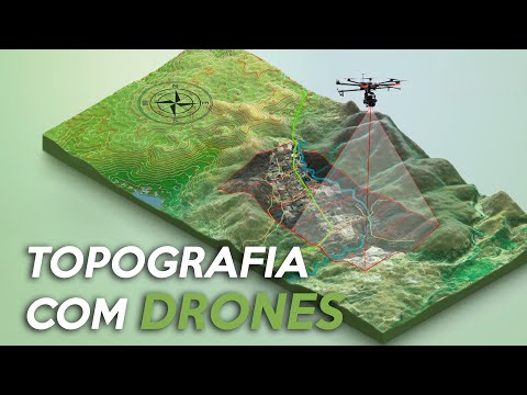
TOPOGRAFIA com DRONES! Conheça o FUTURO da TOPOGRAFIA moderna
54.55k views1143 WordsCopy TextShare
Engenharia Detalhada
A topografia é uma ciência bem antiga e popular dentro das geociências. Basicamente, ela é realizada...
Video Transcript:
Drnes have become fashionable in recent times, whether you want to shoot something from the heights, or take that photo of places that are difficult to access. But they go much further than just taking pictures and filming. Today we are going to talk about topography using drones.
What's up engineering lovers, my name is Igor Felipe and it is always a pleasure to see you here on the channel. In todays topic, we vamosre going to talk a little about the use of drones to generate topographies, or georeferencing. And before you forget, help us by clicking on the like button and if you are not subscribed yet, subscribe to the channel, ok?
Topography is a very old and popular science within the geosciences, and it basically serves to have the topographic profile of the terrain. And when I say topographic terrain profile, I mean its elevations, coordinates, distances and all necessary terrain information. Today it is carried out by field operators, who we call surveyors, and they roam the terrain with equipment they call a total station.
They collect reference points, distances, angles and heights, and with that they end up creating reference planes that describe the terrain information. Previously, this information was collected through another equipment, which was called theodolite. It had the same function as the total station, but the total station is more digital and electronic, and the theodolite was completely manual and analog.
And not only with this equipment that we end up collecting information, but also with GNSS receivers, the famous GPS or RTK, which together with other equipment, help and facilitate this survey of the terrain. But the advances did not stop there. One of the limitations that the equipment I mentioned has is that it is necessary for workers to cover the entire terrain, or at least a large part of it on foot.
This makes this survey time consuming and even difficult to carry out. Just think if we have to do a topographic survey of a road that connects Pará to São Paulo, passing through dense forests and closed terrain. Surveyors will have a lot of work to do this survey.
And to facilitate this process, it is now possible to perform the topography of the terrain using drones. "Drne topography", or speaking in a more technical term, "drone photogrammetry", is the science that captures information from objects on the ground without direct contact between it and the sensor, that is, you don't need to traverse the terrain to capture information, you can do it remotely. As we already use drones to collect information from the terrain and they have equipment and sensors that help in collecting this information, why not use drones to our advantage.
The use of drones to collect information from the terrain brought significant changes, such as: The decrease in equipment costs Decrease in field teams Increased data acquisition speed in the field And ease of operation And not only that, because to open a company In the past, you had to buy an airplane, expensive sensors to board, work with high fixed costs like pilot and hangar rental , and high variable costs like aircraft maintenance, sensors and fuel. Today, the drone has the same capabilities as equipment that fits in a backpack. It is possible to carry out the entire operation with just one man in the field and depending on the drone's operating radius , he will be able to operate the equipment remotely.
It is important to note that although we call these equipment drones, in fact the correct term is UAV, which means unmanned aerial vehicle. In UAV operation, you can plan the flight before going to the location through an online map, load the drone with this survey, go to the desired location, assemble the equipment, take off and monitor in real time all the information collected. It's that simple.
But how is this topographic survey carried out? The topographic survey with drone is done from a mapping flight using sensors, an on-board GPS and can also include an RTK, which means real time kinematic. Since the GPS embedded in drones has a margin of error that can reach 5 to 10 meters, with RTK, it helps the GPS to interpolate its coordinates more accurately, reaching an error margin of centimeters.
The survey is carried out from photos taken with the drone, and coordinates and elevation information from GPS and RTK. From these photos taken by the drone, image processing is carried out, transforming the sequence captured during the flight into what we call a point cloud. While with the total station we raise some points to define the terrain, with the drone we can generate millions of points in a matter of minutes with just the images taken.
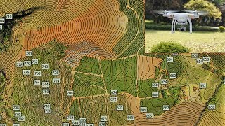
There are different ways to process your drone images. You can send this survey to a company and process this survey in the cloud, or use a software to process these images as is the case I'm going to show you now. In this image, we can see a cloud of points from a survey carried out.
We cannot distinguish the terrain very well with this point cloud, which is why we must treat this point cloud, or rather, the information from all these points to help us. At the end of this point cloud treatment, we ended up developing a triangulated terrain mesh , where the points are connected in such a way that small triangles are formed. And we call this process triangulation.
After going through several stages of treatment, we will have the complete profile of the terrain, being able to generate contour lines and even check the precise coordinates of a pole or the elevation of a particular point, for example. And not only that, we can also use this survey to calculate volumes and areas much more accurately, as we have real images of the site to help us as a reference. Drne surveying, or rather photogrammetry using Vants, ends up turning every pixel of the photos taken into reference points, and in every pixel, it encapsulates coordinate and elevation information to generate the survey we're looking at.
This shows how technology ends up helping us in the development of activities. What used to be done in the field, by several people under the sun, going through dense woods and risks for employees, now everything can be done by one person, in a car at a distance using a drone. I've separated two videos on the side that I'm sure you'll like, so be sure to check it out.
If you've made it this far I'll ask you to like the video, subscribe to the channel, and don't forget to activate the bell .
Related Videos

9:04
Como funciona o GPS? Por que o GPS é impor...
Engenharia Detalhada
55,711 views

31:51
Koenigsegg CEO: "Our NEW Engine Will OBLIT...
The Crow
33,802 views
13:10
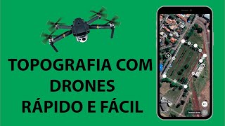
Topografia com Drones, aprenda agora !
Maps4me
58,741 views
10:49
O que é MÁRMORE? Porque o MÁRMORE é tão VA...
Engenharia Detalhada
65,460 views

59:16
Secrets of $3.2 Billion SuperYacht Factory...
Machinatus
89,169 views

8:29
O que é LUZ XENON? Como funciona a LUZ XEN...
Engenharia Detalhada
69,246 views

11:12
The Mysterious Disappearance of 10 Billion...
SciShow
234,196 views
15:59
PLANO DE VOO PARA DRONE DE MAPEAMENTO #4
Piloto de Drone Raiz
17,265 views

12:20
Como funciona um TERMÔMETRO? Quais os tipo...
Engenharia Detalhada
9,484 views
23:12
Uso de drone da linha DJI Phantom em lava...
Marcio Carvalho
116,089 views

37:01
OpenDroneMap - 1) Gratuito e melhor que Me...
SPAMLab IAG-USP
38,457 views
11:10
O que é AEROGEL? Quais são as APLICAÇÕES d...
Engenharia Detalhada
7,265 views

6:26
UNITED KINGDOM tests houses for HYDROGEN. ...
Engenharia Detalhada
73,148 views
19:27
Aprenda Truques Para Elevar seu Nível de D...
Mochila Cheia
382,274 views
50:27
Transporting Millions of Sheep This Way – ...
Agriculture Insight
30,019 views

22:18
Planejamento de voo para mapeamento usando...
Drone Experts
15,156 views
19:16
MAPEAMENTO AUTOMÁTICO - DJI AIR 2s - Drone...
ASX Loja Online
53,628 views
4:24
DRONE PARA TOPOGRAFIA: QUAL COMPRAR?
Software Mappa
23,590 views
13:45
COMO MONTAR E ATIVAR BASE D-RTK2 PARA MAPE...
Piloto de Drone Raiz
5,454 views
23:03
Plano de Voo com correção altimétrica para...
Quantum Geotecnologia
57,743 views