What Causes the Worst Cyclones (It’s Not Just Heat)
1.22M views2838 WordsCopy TextShare
Real Science
Be one of the first 200 people to sign up with this link and get 20% off your subscription with Bril...
Video Transcript:
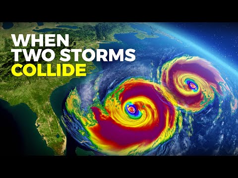
on Thursday September 7th of 2023 hurricane Lee redefined what it means for a storm to rapidly intensify beginning in the North Atlantic and moving steadily towards the Caribbean islands Lee strengthened from a category 1 storm to a category 5 storm in a span of just 24 hours in the past scientists considered a storm to rapidly intensify if it sustained winds increased by 35 miles or 56 kilometers per hour in 24 hours but over the course of one day hurricane Lee increased by 80 miles or 129 kilometers per hour over double what is considered a startling increase this made Lee the third fastest intensifying Atlantic hurricane on record Lee was the first Category 5 hurricane of the 2023 season its wind speed soon went back down causing the storm to fluctuate between Category 3 and 4. but the significance of this storm's Behavior remains storms are getting bigger doing so more quickly and there seems to be more of them than ever in some recent years there were so many storms that forecasters ran out of names and had to resort to backup lists in 2020 there were a record 30 named storms at the time of writing this so far in this year's Atlantic hurricane season there have been 13 named storms and five full-blown hurricanes many of them happening at the same time right now hurricane Lee and hurricane Margot are both tangoing in the Atlantic each creating massive waves winds and rainfall if you live in a coastal area this is all alarming enough but there is another question that all of these storms happening at the same time brings up what are the factors that can turn these storms from a regular storm to a city destroying Nightmare and as our oceans warm and more storms form every day there is perhaps an even more terrifying thought can these hurricanes even combine to create one world altering hurricane how big were the biggest Cyclones in history and should we be bracing ourselves for more of these gigantic storms [Music] hurricane is just one of the many names given to these brutal storms the official term is tropical cyclone and as the name suggests they all form over the tropics in these regions near the equator ocean temperatures reach at least 26 degrees Celsius these high temperatures along with winds blowing across the ocean cause the water to evaporate this creates warm moist air that rises High into the atmosphere where it forms big storm clouds this cycle repeats as new cooler air fills in the space above the hot water then warms and Rises as well the rotation of the Earth causes the strengthening system to spin once the spinning winds reach 118 kilometers per hour the storm is classified as a tropical Cyclone on average they can grow to a diameter of nearly 500 kilometers but there have been some record-setting Cyclones that have grown to thousands of kilometers wide but the anatomy of a tropical Cyclone is a lot more intricate than most images suggest there is a lot going on below the clouds the center where the warm air is rising and cool air is falling is known as the eye of the storm here it's calm with wind speeds staying below 24 kilometers per hour it's also clear as the moving air suppresses cloud formation but just outside of the eye it could not be more different this is called the eye wall in this ring of clouds are heavy rains and the strongest Winds of cyclone beyond the eye wall are the rain bands these are bands of clouds that spiral out from the center you can see their characteristic pinwheel shape in radar images as their name suggests they often release rain but they can also produce tornadoes finally resting on top of the eye wall and Rain bands is the dense cloud cover but without moist heat from the warm tropical oceans even the most powerful tropical Cyclone will break down this is why they quickly weaken and slow down when they travel over land meet dry winds or move outside of the tropics over colder water however it can take some time before they fully dissipate even over dry land and in the meantime there are strong winds and rain can wreak havoc on homes and businesses along the path many tropical Cyclones travel out of the tropics and become mid-latitude Cyclones when they do they undergo what's called an extra tropical transition lacking the necessary warm temperatures to maintain their symmetrical pinwheel shape the cyclone disarranges and spreads out forming more of a camo-like shape these extra tropical storms are common in the West Pacific and North Atlantic oceans and although they are no longer technically a hurricane they can still generate lots of rainfall large waves and even hurricane-like winds which may be why we often still refer to them as hurricanes for instance Hurricane Sandy which struck New Jersey and New York in 2012 transitioned into a mid-latitude cyclone just before it hit but even so its wind speed reached 145 kilometers per hour overall Sandy devastated the East Coast causing 70 billion dollars in Damages destroying 650 000 homes and killing 72 people but while its effects were truly horrific it's a far cry from the biggest and most destructive tropical Cyclones in history in October of 1979 a disturbance in the weather was reported near Micronesia monsoons in this area are common at that time of year so at first this was nothing out of the ordinary but then three separate storms began to form at the same time at first these storms competed with each other preventing any significant growth but soon they were each strong enough to become named typhoons and then something remarkable happened the outflow from the easternmost storm storm Roger started to Veer towards the central typhoon typhoon tip this would become the fuel that would allow typhoon tip to become the largest most intense storm ever recorded on earth soon typhoon tip grew to a diameter of over 2 000 kilometers which is about half the size of the United States its wind speeds reached a whopping 306 kilometers per hour its Central pressure which is an indication of the strength of the storm where lower values correspond to a stronger storm dropped to 870 millibars the lowest sea pressure ever recorded in a storm luckily by the time it made landfall on the Japanese island of Honshu on October 19th it had substantially weakened and soon dissipated on October 22nd even so it produced enough rain to cause over 600 mudslides flood over 22 000 homes destroyed 27 Bridges and 105 dikes and killed 99 people what happened with Typhoon tip was an incredible instance of a smaller storm fueling a bigger one but could typhoon tip have become even larger if the two storms fully combined on September 1st 2022 Category 5 typhoon hinem Noor the strongest tropical Cyclone of that year was barreling towards Taiwan from the Western Pacific Ocean at the same time a tropical storm named gardo was traveling in this same direction as the two storms got close to each other something strange happened they started to swirl around one another until hinam Noor completely devoured gardo this was a textbook example of a phenomenon known as the fujiwara effect however when one storm devours another its intensity doesn't always increase in this case hinam noor's intensity actually decreased but as our oceans continued to get hotter a merger between two large enough tropical Cyclones could lead to the formation of a mega Cyclone causing utter Devastation but what's more likely to happen when two storms get close to one another is not that they merge and become one Mega storm but that their paths become completely unpredictable this is what happened in the case of typhoon's Parma and malor in 2009. the interaction of these storms caused Parma to gain strength and make several u-turns and become stagnant over the Luzon region of the Philippines this erratic Behavior also prevented scientists from being able to provide people with the early warning that they would need to get themselves to safety but storms don't need to interact to become record-breaking monsters currently the longest live tropical Cyclone is Freddy which occurred earlier this year unlike most tropical Cyclones Freddie took an interesting path traveling over 8 000 kilometers it formed on February 3rd just Northwest of Australia traveled across the entire Indian Ocean and made landfall on the eastern coast of Madagascar on February 21st then it traveled across the Mozambique Channel where it made landfall in Mozambique on February 24th before traveling back into the channel circling around and then making landfall again in Mozambique on March 11th where it finally dissipated overall it lasted 36 Days across these regions Freddy caused massive damage and took the lives of over 300 people but despite its longevity this was nowhere near the deadliest tropical Cyclone that took place in 1970 on the coast of Bangladesh with a death toll of an estimated 500 000 people and some estimates are even higher this was the great bowl of cyclone and it made landfall in what was then East Pakistan from November 12th to the 13th while wind speeds were lower than both Cyclone Freddy and typhoon tip reaching 225 kilometers per hour and Central pressure dropped to just 950 millibars the high number of fatalities was a direct result of the geography of this region Bangladesh is densely populated consisting of low-lying islands and tidal Flats about 35 of the area is less than six meters above sea level and more than 20 percent of the country experiences yearly flooding in addition the coast is shaped in a way that funnels in Cyclones from the Bay of Bengal to make matters worse communication with most people living along the coast and on the islands was impossible so while meteorologists knew of the incoming Cyclone they had no way to warn and Evacuate the area but this was just one major storm in a series of devastating weather events that have impacted this region in fact seven of the nine deadliest weather events of the 20th century were tropical Cyclones that struck Bangladesh more recently in 1991 another severe Cyclone made landfall in the area drowning 140 000 people this number could have been much higher but thankfully warning and evacuation systems were in place allowing for several million people to be evacuated ahead of time and as storms batter the coast this time of year there is a pervasive narrative that there are more storms than ever and that they're getting worse but is this true we know that giant Cyclones have been a Scourge for as long as humans have had records are the storms now truly a result of climate change using satellite data scientists can monitor the strength duration and frequency of storms they can use this information to analyze how the intensity of tropical Cyclones has been changing as our climate has warmed they do so with two calculations that use wind speed measurements and both have been increasing data on tropical storms in the North Atlantic have shown that the total accumulated Cyclone energy index has been significantly above the normal threshold since the mid 90s and the power dissipation index has pretty much followed the rising sea surface temperatures caused by global warming but this hasn't necessarily led to an increase in the frequency of tropical Cyclones though it's hard to say for sure there have been a lot of changes in weather collection technology over the years for instance aircraft data collection began in only 1944 and satellite tracking started in 1966.
this makes it difficult to know the exact number of tropical Cyclones that have happened before we had these capabilities and those that never impacted any humans either at sea or on land would have gone unnoticed however while determining the exact amount of cyclones that we never noticed may be nearly impossible scientists have found a way to estimate it in a study published in 2010 researchers used ship traffic records of boats traveling in the North Atlantic Ocean during the pre-satellite years based on the trajectory and any alterations to their route the researchers approximated the number of missing tropical Cyclones in the record and analyzed how the frequency changed each year overall they found that the number of annual tropical Cyclones is not increasing and that there have been no significant changes over time but while the frequency may not be increasing the strength and duration of these Cyclones definitely are that's because warmer water means more fuel for these storms in a study evaluating the intensity of tropical Cyclones over the last 39 years researchers found that the number of major Cyclones increases by about 10 percent from 1988 to 2007 or about 5 Each decade while the number of minor ones is decreasing looking forward computer models predict that in just the next few decades tropical Cyclones will be 24 wetter have 13 percent stronger winds and be 17 percent slower altogether this amasses two powerful lingering Cyclones capable of dumping massive amounts of water in one area as well as giving the strong winds more time to assault buildings and trees while these are just predictions one thing that we know for sure is that sea levels are rising since 1900 the average sea level has risen over 15 centimeters and it's expected to continue to increase for at least another 30 by the end of this Century this increases the risk of flooding along coastal regions we've already seen how this has intensified the impact of recent tropical Cyclones such as Hurricane Katrina in 2005. a study published in 2014 estimated that flood elevations experienced during the Cyclone were 15 to 60 percent higher than they would have been in 1900. this equals 0.
8 to 2. 4 meters of water because of all of this scientists are working on better forecasts that won't only tell us details on the characteristics of a storm but what types of Damages it will create and how it will impact a community this will help develop better Warning Systems and improve the planning of evacuations because as the earth's climate gets hotter there's a big chance that the most severe storms are yet to come to me sometimes it feels like predicting the weather is basically Magic how can they know that a particular hurricane is going to make a hard right turn or that the weather 10 days from now is going to cool off and yet forecasters usually get it more or less right imagine telling your ancestors about this ability we can literally tell the future at least in this one specific domain it might feel like magic but weather forecasts are actually made by collecting data about the current state of the atmosphere and using an understanding of atmospheric processes to predict how the atmosphere will evolve its data and its probability these are some of the most powerful tools that the world of mathematics gives us and surprisingly there is a free and easy way to learn more about them brilliant. org has so many courses on subjects just like this and it's the best way to learn math data science and computer science interactively I've always struggled with lectures and textbooks but brilliant is an Interactive Learning environment where less are structured around things that feel more like games and puzzles than like college coursework there are levers sliders and buttons so you can test theories and visualize high level Math and Science Concepts the exploring data visually course has been particularly helpful in visualizing Concepts that can be otherwise hard to wrap your head around lessons within this course like the filtering data lesson teaches you to toggle different filters to understand the best way to visualize the data you're working with or there's the predicting probability course that teaches you how to harness data to predict future outcomes in adult life we are constantly making decisions so so so many decisions and understanding probability can really help you feel more competent and confident in the choices that you make from choosing an airline while traveling to investing to planning an outdoor event brilliant has thousands of lessons like this from foundational and advanced math to AI to data science and neural networks and more with new lessons added monthly so to better learn how to confidently navigate this world of overwhelming numbers and to try everything that brilliant has to offer free for a full 30 days visit brilliant.
Related Videos

52:58
Rise of the Superstorms Full Special | PBS...
PBS America
752,397 views

1:22:28
Tsunami: the moment when everything change...
Investigations et Enquêtes
29,871,693 views

16:57
What Happened To The Nautilus?
Mustard
10,922,524 views

16:38
Why Animals Get Creepier the Deeper You Go
Real Science
2,731,472 views

18:07
New Evidence We Are Entering An Ice Age Te...
Dr Ben Miles
3,010,426 views

22:07
The Insane Story Of The Deadliest Storm In...
Joe Scott
1,805,888 views

14:42
What Happens If Yellowstone Blows Up Tomor...
RealLifeLore
12,897,925 views

18:22
The Insane Biology of: The Narwhal
Real Science
592,582 views

29:28
Storm Chasing In A $750,000 Tornado-Proof ...
Supercar Blondie
2,417,779 views

18:56
How Cell Service Actually Works
Wendover Productions
2,911,766 views

15:02
What El Niño Will do to Earth in 2024
Astrum
6,942,815 views
37:54
What's Hidden Under the Ice of Antarctica?
RealLifeLore
4,261,806 views

15:59
The Secret Language of Trees
Real Science
2,219,084 views

22:11
Storm Chasers🌪️ | Weird But True! | S1 E2...
Nat Geo Kids
460,559 views

10:49
What Would a Trip to the Mariana Trench Be...
BRIGHT SIDE
36,728,596 views

16:54
Can We Stop Asteroid Bennu?
Dr Ben Miles
814,876 views

19:13
Why Do Deep Sea Creatures Evolve Into Giants?
Real Science
8,159,587 views

29:53
The Deadliest City on Earth
Faultline
281,417 views

19:02
These Images Explain Why Venera Went Silen...
Astrum
1,130,330 views

25:54
The Insane Biology of: The Orca
Real Science
6,746,464 views