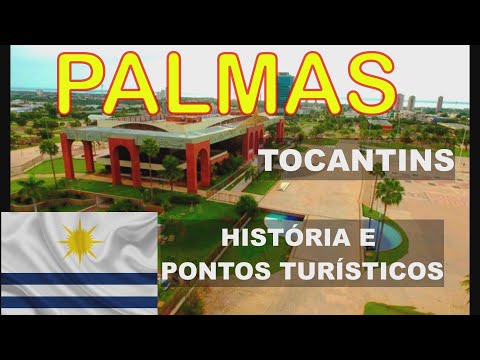
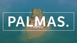
PALMAS, TOCANTINS | HISTÓRIA E PONTOS TURÍSTICOS
29.93k views2233 WordsCopy TextShare
Terra Vídeos
Conheça a História e os Pontos Turísticos de Palmas, Capital de Tocantins.
Palmas é um município br...
Video Transcript:
PALMS. TOCANTINS. Palmas is a Brazilian municipality, capital and also the largest city in the state of Tocantins.
The city was founded on May 20, 1989, shortly after the creation of Tocantins by the 1988 Constitution, by Governor José Wilson Siqueira Campos, who commissioned, through a contract, the architects Luís Fernando Cruvinel Teixeira and Walfredo Antunes de Oliveira Filho, to carry out of architectural and urban design. From then on, the city began to be built by workers who came from the interior of Tocantins and from several other states in the country. However, it was only from January 1, 1990 that Palmas became the definitive capital of the state, since before that the city still did not have the physical conditions to host the state government, which was temporarily allocated in the neighboring municipality of Miracema do Tocantins.
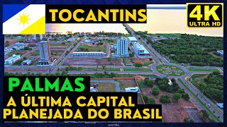
Palmas is the last completely planned city of the 20th century, since the city was born and designed from the beginning to be the capital of the state of Tocantins, being also the newest state capital in the country. The municipality is also characterized by having the best quality of life among the capitals and municipalities of northern Brazil. The growth of Palmas was too much during the 1990s.
In 1991 the city had a population of 24,261 inhabitants. In the year 2000, the city already had 130,528 inhabitants, and in 2021, 313,349 inhabitants. Its urbanization has also grown in recent years.
Despite a slowdown, Palmas has an economic growth of 8. 7%, higher than the national and state index. The name to baptize the capital of Tocantins, Palmas, was chosen in honor of the Comarca of São João da Palma (currently Paranã), headquarters of the first separatist movement in the region, installed in 1809 on the bar of the Palma River with the Paranã River.
Another factor that influenced the name was the large amount of palm trees in the region. The history of Palmas is closely related to the history of its state. The area where Tocantins is located today was the north of the state of Goiás and since the 19th century there have been some separatist movements in the region.
In 1809, a separatist movement in the region of Goiás called Vila da Palma was installed on the bar of the Palma River with the Paranã River. In 1821, after the isolation of that region provoked by King João VI of Portugal, it caused another separatist revolt, when Judge Joaquim Teotônio Segurado proclaimed an autonomous government for that region. However, in three years the revolt was contained by Caetano Maria Gama, president of that province, appointed by Dom Pedro I, then emperor of Brazil.
The division of Goiás remained dormant until the 1970s, when it was discussed in the National Congress, and approved in 1988. Only years later, with the dismemberment of the state of Tocantins from the state of Goiás by the 1988 Constitution, did Palmas finally started to emerge. On January 10 , 1989, the city of Miracema do Tocantins was defined as the provisional capital of the state.
On February 15, 1989, the Assembly authorized the then governor Siqueira Campos to expropriate the area of Serra do Carmo and east of the town of Canela for the creation of the new state capital idealized by the then governor. On March 6th of the same year, by decree, the Commission for the Implementation of the New Capital (Novacap) was created and, on May 20th, 1989, the cornerstone of the city was laid, in a ceremony that brought together about ten thousand people in Praça dos Girassóis. On the same day, Governor Siqueira Campos activated the tractor, opening Avenida Teotônio Segurado, the first arterial road in the city.
Much of the municipality was built by workers from various locations in Brazil. On July 19 of the same year, the Constituent State Assembly approved the executive bill creating the Municipality of Palmas. The law was sanctioned on the following August 1, when Siqueira Campos confirmed the transfer of the capital from Miracema do Tocantins to Palmas.
It was only on January 1, 1990 that Palmas assumed its function as the state capital and the constituted powers were transferred from the provisional capital, Miracema, to the master plan of the new city. However, government offices did not yet exist and did not have accommodations to house administrative staff. The first mayor of the municipality was Fenelon Barbosa Sales.
Today, the population of the city already exceeds three hundred thousand people. A planned city, it was built with wide avenues, efficient environmental preservation and good public places. Palmas was the capital with the highest demographic growth during the first decade of the 21st century.
Palmas is the capital of the twenty-fourth most populous state in Brazil, Tocantins, located at the geographic coordinates 10° 11' 04" south and 48° 20' 01" west, with the 10th parallel south and the 48th meridian west passing through within the municipal territory. The original area of the municipality of Palmas, according to the IBGE is 2219 km2. Its altitude is 260m.
The municipalities neighboring Palmas are respectively: Lajeado and Aparecida do Rio Negro to the north; Novo Accord and Santa Tereza do Tocantins to the east; Monte do Carmo to the southeast and south; Porto Nacional to the south, southwest and west; and Miracema do Tocantins to the northwest. The relief is characterized by the Serra do Carmo and Serra do Lajeado, which are basically a rugged relief , with the city remaining on a 'plain' between the Serra and the dammed lake. The main river that runs through the municipality of Palmas is the Tocantins River.
The stretch of this river that bathes the municipality is part of the lake formed by the Lajeado Hydroelectric Power Plant, which is located just over 54 km north of the city, in the neighboring municipality of Lajeado. Among the other watercourses that pass through the municipality, the Rio das Balsas, the Ribeirão das Pedras, the Ribeirão Taquaruçu, the Córrego Macaco and the Ribeirão Taquaruçu Grande stand out. Palmas has excellent sights to be visited.
Praça dos Girassóis, located in the center of Palmas, is considered the largest square in Latin America and one of the largest in the world, with 571,000 m2. Its construction began in 1999 and was inaugurated on September 7, 2000. In addition to containing several monuments, the square is home to the headquarters of state public authorities: Executive (Palácio Araguaia), Legislative (Legislative Assembly of the State of Tocantins ) and Judiciary (Tocantins State Court of Justice).
As well as government departments . The large sidewalk of Portuguese stones and gardens, located in front of the palace, seen from above show the map of the state of Tocantins. In the middle of the sidewalk is the landmark of the Geodesic Center of Brazil, the central point between the extremes of our country (north-south, east-west).
Praça dos Girassóis has many of the tourist attractions in Palmas. There are several architectural monuments, memorials and a beautiful fountain. The Araguaia Palace is the seat of the Government of Tocantins, located in the center of Praça dos Girassóis.
It has an area of 14,000 m2 and is one of the main postcards of the city. Its architecture is very imposing, with red arches on its facade in honor of the Church of Nossa Senhora do Rosário. The façade also features spheres measuring 4 meters in diameter.
The entrance porticos are 5 meters high and 30 meters wide. Fountain at Praça dos Girassóis. The fountain draws a lot of attention for its beauty, located at the back of the palace.
The fountain has a beautiful landscaping, formed by an artificial waterfall, which flows into three pools. It is also illuminated by 64 LEDs and 16 pumps that form a fountain 15 meters high. The Memorial Coluna Prestes is also located in Praça dos Girassóis.
Work of one of the greatest architects in history, Oscar Niemeyer, the Memorial It was built to honor the political-military movement Coluna Prestes, has a beautiful look, in addition to the statue in front of it. The building's architecture carries the curvilinear features of Niemeyer's works, and has exhibition rooms that display photographs, and an auditorium with capacity for almost 100 people. Monument to Eighteen of the Fort.
Inaugurated on October 5, 2001, the monument honors the revolution against the Old Republic. The 18 statues represent the garrison of soldiers who kept the Fort of Copacabana and the School in Realengo standing. The statues are arranged on stone formations that represent the sidewalks of Avenida Atlântica.
The statue further ahead represents Lieutenant Siqueira Campos, one of the leaders of the revolt, who carries a Brazilian flag. The monument is also located in Praça dos Girassóis, close to the Memorial Coluna Prestes. Monument to the Pioneers of Palmas.
The work of the carioca sculptor Mauricio Bentes, the monument honors the first family that moved to the city of Palmas during its construction and helped in the initial works. The sculptures are made of bronze and represent the family, consisting of nine members: father, mother, sons, daughters and a sheep. The biggest one is 2.
36 meters high and the family is in a position of gratitude for being part of the history of the city of Palmas, Tocantins. Caesar Park. Created in 1998, Cesamar Park has an area of 96,770 m² of biological reserve.
It is a shelter for several animals, such as macaws, parrots, monkeys, armadillos, capybaras and many others. The park also houses the lake of the Córrego Brejo Comprido basin, where pedal boats are held and there are beautiful artificial waterfalls. The place has restaurants, places for skating and other sports and also houses Casa Saçuapara, headquarters of the first City Hall and City Council of Palmas, which today is a small museum.
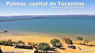
Fernando Henrique Cardoso Bridge, also called the Friendship and Integration Bridge, was inaugurated in 2002. In fact, it is a complex of bridges and landfills that connect Palmas to the district of Luzimangues, in the municipality of Porto Nacional. The entire complex is 8 km long, between four embankments and three bridges, two 100-meter bridges and another 1,042-meter long bridge, which crosses the Tocantins River.
The river was widened by the dam at Usina Luis Eduardo Magalhães, located 60 km north of Palmas. Graciosa Beach. Praia da Graciosa is one of the beaches in Palmas, Tocantins, due to its central location in relation to the center, located right next to the bridge, in an area full of restaurants and sidewalks.
The beach is 500 meters long and has an excellent structure for food and hygiene. At night, the place is very busy as it is the main gastronomic center of the city of Palmas. The beach has sports courts, space for children's recreation and a lot of green area, with trees and plants that give an even more natural touch.
The place offers the best view of the bridge and the sunset, and is also the departure point for boats to Ilha do Canela. Surrounded by the waters of Lagoa de Palmas, Ilha do Canela is the most famous and beautiful beach in Palmas. The island has an area of 45,000 m2, and is just over 3 km from the Graciosa beach pier where boats leave.
It is known as the Oasis of the capital of Tocantins and is privileged with a spectacular sunset. The island offers excellent infrastructure with restaurants, waterside kiosks and even a camping area. On site there are also some water activities available.
Silver Beach. Among the beaches in Palmas, Praia do Prata is the most visited because it has several restaurants and huge kiosks on the riverside. In addition to the restaurants serving typical food from the state, the camping area, sports courts and leisure areas.
With clear waters and pleasant temperatures, the beach has several tables with straw covers along with the water of Lago de Palmas. The beach also hosts cultural and sporting events and festivities. It is about 9 km from the city center.
In addition to these, there are still several other tourist attractions in Palmas. Palmas is considered one of the hottest state capitals in Brazil today. The tropical savannah climate predominates (Aw, according to the Köppen-Geiger climate classification), hot all year round, with low temperature range.
The average annual compensated temperature is 27 °C. The seasonal distribution of rainfall is well characterized, in the year, by two well-defined periods: the rainy season, from October to April, with an average temperature of 26 °C, with light and moderate winds; and the dry season, from May to September with an average temperature that varies between 23 °C and 27 °C. The annual rainfall is greater than 1 800 millimeters (mm).
During the dry season, air humidity plummets, and may be below 15%. According to data from the National Institute of Meteorology (INMET), the highest maximum temperatures recorded at the city's meteorological station are: 43. 0 °C on October 25 , 2017; 42.
4 °C on September 13, 2019; 42. 3 °C on October 21, 2017; 42. 1 °C on October 16, 2015 and 42.
0 °C on September 29, 2017. The lowest temperature recorded in Palmas since 1993 (as of November 25) was 11. 5 °C on the 21st August 1994 and July 12, 1996.
The highest cumulative 24-hour rainfall was 156. 5 mm on March 23, 2010. Thank you for watching.
Related Videos
17:08
MORAR EM PALMAS NO TOCANTINS: PONTOS POSIT...
MAIS 50
79,703 views

28:37
O QUE FAZER em PALMAS no TOCANTINS? Restau...
Estevam Pelo Mundo
213,610 views

32:49
GM Palmas - Geografia e Atualidades - Aspe...
VALE CONCURSOS
3,186 views
14:45
PALMAS-TO - UM PASSEIO PELA MAIS NOVA CAPI...
VIAJANDO COM O LUIZ
16,114 views
12:46
PALMAS Tocantins - descubra as Principais ...
Fui Ser Viajante
14,374 views
13:57
PALMAS, TO | 2 dias na capital mais NOVA d...
Rolê Família
9,714 views
21:02
TOP 5 cidades pra viver no PIAUÍ
Coisas do Mundo
823,937 views

11:13
Como é morar em PALMAS | Melhores cidades ...
Família Pet na Estrada 💛
63,952 views
44:59
9500 | História de Tocantins - Movimento S...
canalbackup01
5,796 views
16:14
VALE A PENA CONHECER PALMAS? | Tudo sobre ...
De Repente Nômades
10,791 views

20:40
TOP 10 cidades do interior de GOIÁS para m...
Coisas do Mundo
543,360 views
6:38
CONHEÇA GURUPI A CIDADE AGRÍCOLA DO SUL DO...
Cidades & Cia
35,604 views
17:46
Conheça a Cidade de PALMAS no TOCANTINS | ...
ArrumaMalaÊ
21,917 views
10:08
A Ponte do Lago de Palmas A Historia do To...
HDRONES
12,958 views

12:29
O QUE FAZER em PALMAS no TOCANTINS ? Atraç...
Algum Lugar na Terra
36,511 views
13:48
Praça dos Girassois em Palmas Tocantins
Vanderlan Maciel
26,256 views
15:27
The 10 Brazilian Cities That Grew the Most...
Terra Vídeos
103,594 views
8:50
O que fazer em Palmas
Os Sabores do Mundo
30,639 views
8:25
CONHEÇA A CAPITAL DO CERRADO / GOIÂNIA A C...
Cidades & Cia
52,852 views
5:06
CURIOSIDADES DE PALMAS - TO
Vou na Frente
54,212 views